
Land Use Regulations
The Land Use Rezoning Study was adopted by the City Council on May 25, 2023, and went into effect on July 1, 2023.
Minneapolis 2040 went into effect on January 1, 2020, following over two years of engagement with the people of Minneapolis. The plan guides growth and change with fourteen goals in mind, including eliminating racial disparities, slowing climate change, and increasing access to jobs and housing.
As required by state law, the City updated its zoning rules to match the development guidelines that the City Council approved in Minneapolis 2040. Since 2020, the City has worked to meet this requirement by adopting inclusionary zoning, eliminating single-family exclusive zoning, adopting new built form districts and regulations, and eliminating minimum parking requirements. The Land Use Rezoning Study was the next major update to zoning regulations that created consistency between the zoning code and the comprehensive plan. The comprehensive plan’s 12 Future Land Use categories guided the development of new land use regulations, governing issues such as:
- Uses allowed in each zoning district
- Development standards that apply to uses allowed by zoning district (size of individual uses, where retail mixed-use is required, etc.)
- Creation and mapping of new zoning districts to be consistent with the Future Land Use Map in Minneapolis 2040
![]() How to use this webpage
How to use this webpage
- Read through the Background section to know more about why the City updated the Land Use Regulations.
- Learn more about ordinance by exploring content organized by:
Table of Contents
- Background
- Regulations
Background
MINNEAPOLIS 2040 GOALS
New and updated land use regulations will ensure that key elements of Minneapolis 2040 will be implemented. Climate change resilience and Clean environment through more efficient use of land by setting the stage for more complete neighborhoods and more efficient transportation options and travel patterns. Affordable and accessible housing and Complete neighborhoods by improving access to a variety of land use designations citywide, setting the stage for increased access to goods and services and employment opportunities closer to where people live and work. More residents and jobs by regulating the efficient use of land. Eliminate disparities by ensuring ample access to a variety of land use designations citywide, making it easier to achieve other goals related to complete neighborhoods and transportation access.


Regulations
Primary Zoning District Map
The updated land use regulations resolve conflicts between Minneapolis 2040 and the City’s previous zoning regulations. They provide clarity around which uses are allowed in which district, and whether any special regulations should apply to specific uses.
Minneapolis 2040 includes 12 Future Land Use Districts that guide the development of these regulations, which primarily guide the uses that should be allowed in the city (residential, commercial, mixed-use, production, etc.). The zoning changes described here include 15 new primary zoning districts (replacing the existing 23) that contain land use regulations in accordance with the future land use map and policy guidance that was already adopted by the City in Minneapolis 2040.
Important note: The use of every property in the city will not change between now and 2040. These regulations will provide guidance if a property owner proposes changes to the way a property is used. To see a side by side comparison of existing primary zoning and proposed primary zoning, follow this link.
Primary Zoning Map:
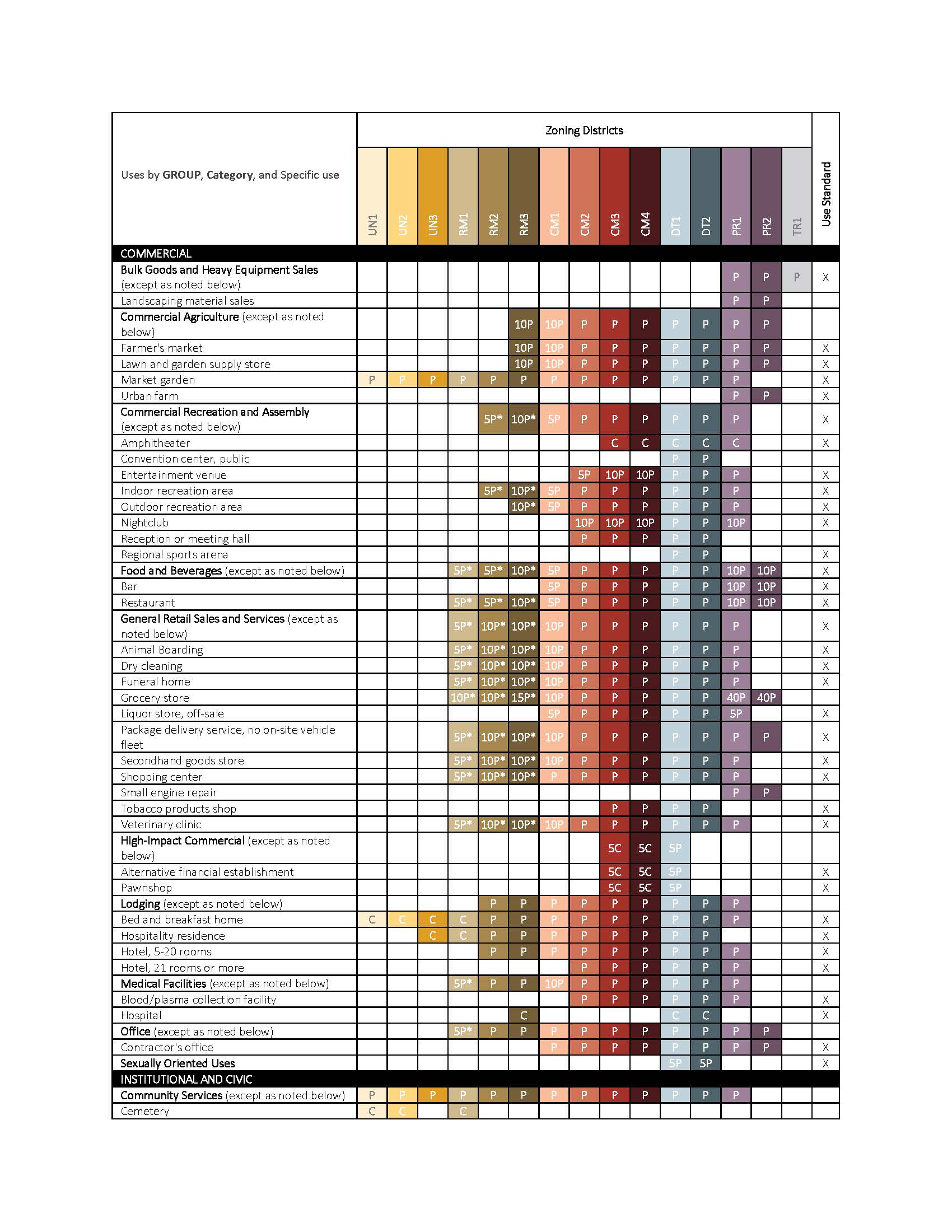
Uses Allowed Table
The Uses Allowed Table lists various types of uses and which of the 15 primary zoning districts the uses are allowed in.
Uses are organized by GROUP, Category, and Specific Use. For example, COMMERCIAL is a use group that includes all uses that are primarily commercial. Within the COMMERCIAL use group are categories such as Food and Beverages, under which all related uses are considered. The Food and Beverages category is defined in Chapter 545 – uses considered part of this category are permitted, conditional, or not permitted in the manner shown in the table for the entire category.
Uses specified with a "P" are permitted as of right in the district or districts where designated. Uses specified with a "C" are allowed as a conditional use in the district or districts where designated. The number preceding a “P” or “C” in the use table indicates the maximum gross floor area for that use in that district in multiples of one thousand (1,000) square feet. An asterisk “*” following a “P” or “C” in the use table indicates that the use is only permitted in a multi-story mixed use building.
Certain specific uses are enumerated in the use table for two reasons: (1) the districts where the specific use is allowed are different from other uses in the use category; and/or (2) the use is subject to specific use standards that are in addition to use standards applicable to other uses in the same use category. In these situations, the use category includes the reference "except as noted below" in the table below.
Content by Land Use Topic
Urban Neighborhood (UN1, UN2, UN3)
Residential Mixed Use (RM1, RM2, RM3)
Commercial Mixed Use (CM1, CM2, CM3, CM4)
Downtown (DT1, DT2)
Production and Production Mixed Use (PR1, PR2)
Transportation (TR1)
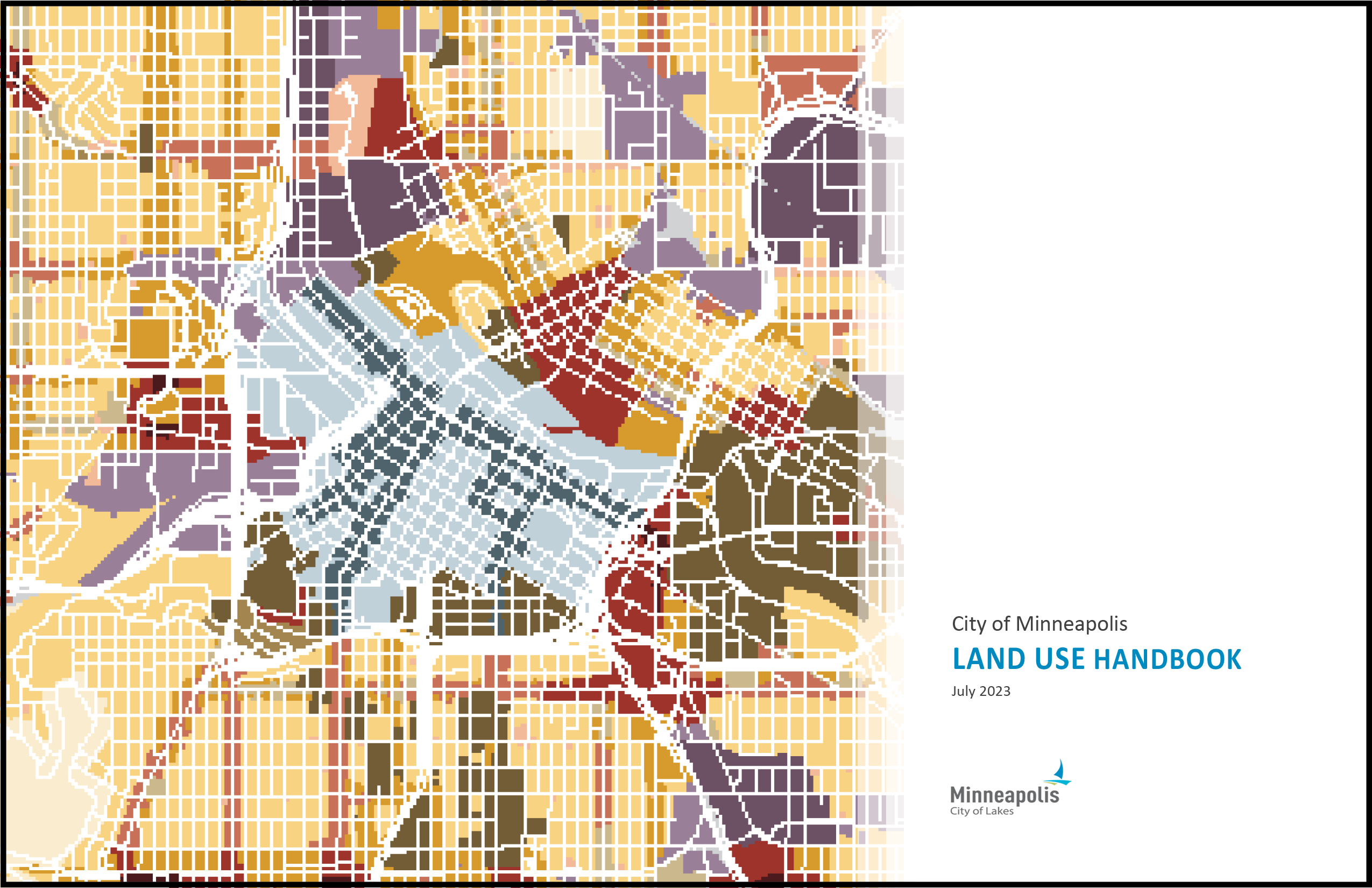
Land Use Handbook
The Land Use Handbook is a quick reference guide, but not necessarily a complete picture of all the City's Land Use regulations in the zoning code! It is still important to connect with a planner from the City of Minneapolis' Department of Community Planning & Economic Development.
Most of the land use regulations are found in Chapter 530 Zoning Districts and Chapter 545 Use Regulations. This quick reference guide provides information on the primary zoning districts and the principal land uses allowed in those districts.
The 15 primary zoning districts are divided into 6 categories grouped by their common characteristics: Urban Neighborhood, Residential Mixed-Use, Commercial Mixed-Use, Downtown, Production, and Transportation. Some of these districts contain district development standards that apply to uses allowed in the district (e.g. where retail mixed-use is required, associated development standards, etc.). The district descriptions and district development standards are included in the Primary Zoning Districts section of this guide.
View the Land Use Handbook below.

Adopted Zoning Ordinance Chapters
Chapter 520 General Provisions
Chapter 525 Administration and Procedures
Chapter 530 Zoning Districts
Chapter 535 Overlay Districts
Chapter 540 Built Form Overlay Districts
Chapter 545 Use Regulations
Chapter 550 Development Standards
Chapter 555 Off-street Parking, Loading, and Mobility
Chapter 560 Signs
Chapter 565 Definitions
Chapter 598 Land Subdivision Regulations
Resources
MEETINGS
Adoption Process:
- Land Use Rezoning Study Legislative File
- Planning Commission Public Hearing – April 24, 2023
- Business, Inspections, Housing, and Zoning Committee – May 16, 2023
- City Council – May 25, 2023
- Ordinance Publication – June 5, 2023
- Effective Date – July 1, 2023
City Planning Commission Committee of the Whole:
April 13, 2023 - CPED staff discussed changes made to the staff-recommended code text and maps since the beginning of the public review period on January 12, 2023.
March 9, 2023 - Staff discussed zoning ordinance revisions intended to implement the future land use policies of Minneapolis 2040.
February 9, 2023 - Staff presented content on a selection of specific uses and how they are addressed in the draft zoning ordinance.
January 12, 2023 – This meeting indicates the start of the 45-day public review period for the Land Use Rezoning Study.
August 18, 2022 – Staff presented an update on the project including information on proposed new primary districts, overlay district changes, commercial use standards, use tables, and code structure.
March 10, 2022 – Staff gave an overview of the process to come, highlighting key considerations and a general timeline of the work.
Public Meetings:
- 45-day (extended) Public Review Period – January 12 through March 26, 2023
- Virtual Public Meeting – 7pm, February 15, 2023
- Presentation Slides
- Questions and Answers